- New

Reference: 9.01.0093
Brand: ROBOROCK
Reference: 55T69C
Brand: TCL
Reference: QE75QN70FAUXXH
Brand: SAMSUNG

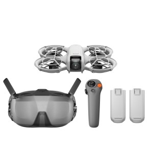
High-Precision Aerial LiDAR System Zenmuse L2
Zenmuse L2 integrates frame LiDAR, a self-developed high-accuracy IMU system, and a 4/3 CMOS RGB mapping camera, providing DJI flight platforms with more precise, efficient, and reliable geospatial data acquisition. When used with DJI Terra, it delivers a turnkey solution for 3D data collection and high-accuracy post-processing.
Data sheet
Specific References
Reference: CP.EN.00000519.02
Brand: DJI
Reference: CP.FP.00000186
Brand: DJI
Reference: CP.MA.00000780.02
Brand: DJI
Reference: CP.FP.00000149
Brand: DJI
Reference: CP.EN.00000555.03
Brand: DJI
Reference: CP.MA.00000815.01
Brand: DJI
Reference: CP.EN.00000558.01
Brand: DJI
Reference: CP.FP.00000184.06
Brand: DJI
check_circle
check_circle